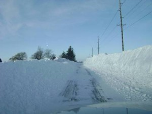
 A strong storm system moved out of the central Plains into Illinois and the Great Lakes on December 19th and 20th, increasing in strength as it progressed northeast. This began spreading snow into the area on Wednesday evening (Dec.19th) with quick accumulations. Snow became heavy and continued across much of the region through the day Thursday (Thursday, Dec.20th) as winds also increased. Blizzard conditions began to develop through the day as winds and snowfall rates increased. The snow gradually pushed off to the east later that night as the storm system exited the Great Lakes, but the winds remained strong – continuing to blow and drift the fallen snow. The highest wind gusts topped out just below 50 mph across northeast Iowa and near 45 mph in southwest Wisconsin.Heaviest snow accumulations extended from parts of northeast Iowa into southwest Wisconsin where 8 to 14 inches was common. Another snowfall band dropped 8 to 11 inches of very “dry, light weight” snow over parts of west central Wisconsin, near Osseo and the Interstate 94 corridor.
In Richland County snow accumulation varied from 10.8″ to 12″ snow, depending on the location.
The fresh snow, combined with peak wind gusts in the 40 to 55 mph range, led to significant drifting, zero visibilities at times, and dangerous travel conditions. This was especially true in open or flat terrain. Sheriffs reports that many people heeded warnings and road traffic was minimal. The emergency declaration has ended for Richland County and road crews continue to clean up from the storm. Local officials urge everyone to give plow trucks plenty of room and be patient as the clean up our streets and roads.
 The blizzard is now peaking and causing road closures, stranded vehicles, and accidents throughout SW Wisconsin. Accident numbers and road closures are increasing areawide, especially from I-90 south. Heavy snow will slowly end during the early evening in Wisconsin. Winds will become the main story, especially in the Blizzard warning as winds will gust to 50 mph through early evening. This snow and wind combination AND nightfall will provide for dangerous whiteout conditions, particularly in flat open areas and higher terrain. Refrain from travel if you can do so.
 For the latest closures or cancellations please stay tuned to WRCO Radio. For a complete list visit the